Contracts & renewals
Re-quote next year from the same takeoff. Change the rate, not the measurement.
Property maps · Pro
Draw the property once and it pays you back twice: measurements that fill in your estimate quantities, and a crew map that tells the truck where the gate is and which side not to mow. Available on the Pro and Scale plans.
The problem
Most quotes in this trade are a windshield guess written down as a fact. It works until the day you need to raise a price and the customer asks why, or until you win a fertilizer account priced on a quarter-acre that turns out to be half of one. Nobody measures, because measuring used to mean a wheel and an afternoon.
The workflow
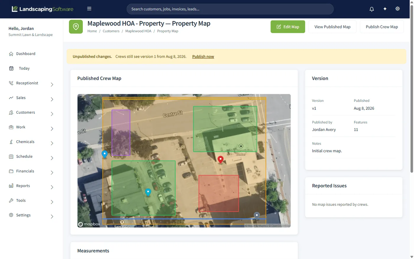
One pass over an aerial, and the same drawing feeds both the office and the field.
1 · Trace
Boundary, turf, beds and no-mow surfaces as areas. Edges, fences and curbs as lines. Gates, hazards, sprinklers and parking as points.
2 · Measure
Turf area, bed area, edging length and boundary area, added up from the shapes as you draw them.
3 · Price
Products priced per thousand, per acre, per linear foot or per hour read the measurement they need. Every quantity stays editable.
4 · Publish
Publishing cuts a version and pushes it to the field, filtered to the services that crew is there to do.
Price increases that survive the phone call
The hardest conversation in this business is the one where a long-standing customer asks why the price went up. "Costs are up" invites a negotiation. A measurement and a rate does not, because there is nothing in it to haggle with.
The same is true internally. When two people quote the same property from the same takeoff, they arrive at the same number, and your margin stops depending on which estimator answered the phone.
When the map is wrong, the crew reports it with a photo and you resolve it from the map page. That loop is what keeps a map worth trusting in year three.
Works together
Re-quote next year from the same takeoff. Change the rate, not the measurement.
The treated area a log needs, measured rather than estimated.
The map in the truck, filtered to the work that crew is there to do.
See how the whole platform fits together, from first measurement to renewal.
Questions
Areas, lines and points on an aerial of the property. Areas are the boundary, the turf you mow, the beds you maintain, and the surfaces a mower must avoid. Lines are edges, fences and curbs. Points are gates, hazards, sprinkler heads and where to park. Each shape gets a label and, if you want, an instruction for the crew.
Four totals, added up from what you drew: turf area from the mow shapes, bed area from the bed shapes, edging length from the edge, fence and curb lines, and the property boundary area. Those are the numbers estimates price from.
Set a product up once with how it is priced (per square foot, per thousand square feet, per acre, per linear foot, or per hour) and which measurement it reads. Add it to an estimate for a mapped site and the quantity fills itself in. Per-hour products use a production rate, so 12,000 square feet at 8,000 square feet an hour comes back as 1.5 hours.
Always. The map fills the quantity in; it never locks it. Every property has something an aerial cannot know about, and the line total recalculates from whatever you leave on the line.
A published crew map, filtered to the services they are actually there to do. Publishing cuts a version, so you can draft changes without them landing in the field mid-week, and every job records which version it is on.
Crews report it against the map, with a photo if they took one, and the issue shows up on the map page for you to resolve or dismiss. A map nobody maintains is worse than no map, because crews stop trusting it, so the reporting loop is part of the feature rather than an afterthought.
The job site. One map serves every job at that address, this season and next, which is why a takeoff you do once keeps paying you back at every re-quote.
Property maps are available on the Pro and Scale plans.
14-day free trial · No credit card required